"크래스티드 뷰트 (Crested Butte)"의 두 판 사이의 차이
(→401 트래일) |
(→겨울스포츠 (스키)) |
||
| (한 사용자의 중간의 편집 9개 숨겨짐) | |||
| 5번째 줄: | 5번째 줄: | ||
== 산악자전거 == | == 산악자전거 == | ||
| + | [[Image:2009-CO-08-24.jpg|thumb|left|350px|401 트래일 정상에서 보는 Treasure (13,461 ft), Snowmass(14,091), Maroon Bells(14,156), Pyramid Peak(14,018)]] | ||
=== 401 트래일 === | === 401 트래일 === | ||
콜로라도 주 (Colorado) 크래스티드 뷰트 (Crested Butte)에 위치한 세계적으로 유명한 산악자전거 코스; 물론 하이킹으로도 유명하다. | 콜로라도 주 (Colorado) 크래스티드 뷰트 (Crested Butte)에 위치한 세계적으로 유명한 산악자전거 코스; 물론 하이킹으로도 유명하다. | ||
| 42번째 줄: | 43번째 줄: | ||
크리스티드 뷰트 지역에서 401 다음으로 유명한 트래일; 401 보다 더 태크니칼한 섹션이 많음 | 크리스티드 뷰트 지역에서 401 다음으로 유명한 트래일; 401 보다 더 태크니칼한 섹션이 많음 | ||
| − | === | + | === 그리고 === |
이외에도 좋은 산악자전거 트래일이 많이 있다. 크래스티드 뷰트에 도착하면 호텔이나 자전거 대여점에서 트래일 맵을 구할 수 있다. | 이외에도 좋은 산악자전거 트래일이 많이 있다. 크래스티드 뷰트에 도착하면 호텔이나 자전거 대여점에서 트래일 맵을 구할 수 있다. | ||
| − | == 하이킹 == | + | == 등산 (하이킹) == |
[[Image:2009-CO-08-6.jpg|thumb|right|250px|쿠퍼크릭 트래일에서보는 Judd Falls 폭포]] | [[Image:2009-CO-08-6.jpg|thumb|right|250px|쿠퍼크릭 트래일에서보는 Judd Falls 폭포]] | ||
=== 쿠퍼크릭 트래일 (Copper Creek Trail) === | === 쿠퍼크릭 트래일 (Copper Creek Trail) === | ||
| 52번째 줄: | 53번째 줄: | ||
경사가 심하지 않은 트래일로 사시나무와 돌로 되어있는 산책길을 1 마일 가면 Judd Falls 폭포가 나온다. 이 곳에서 조금만 가면 옆으로 주디 폭포에 접근하는 곳이 나와서 우리 아이들은 밑으로 내려가 잠시 통나무다리를 두팔을 벌리고 오며갔다. 잠시 물가에서 놀다가 올라와 4 마일 가면 Copper Lake 호수 그리고 더 많이 많이 가면 애스핀 (Aspin) 까지 이어진다고 한다. 이 길은 늦은 봄부터 여름에 야생화로 절경을 이룬다. 경사가 많이 없지만 고도가 높아 금방 피로를 느낀다. 하이커들의 컨디션에 따라 하이킹 거리를 정한다. | 경사가 심하지 않은 트래일로 사시나무와 돌로 되어있는 산책길을 1 마일 가면 Judd Falls 폭포가 나온다. 이 곳에서 조금만 가면 옆으로 주디 폭포에 접근하는 곳이 나와서 우리 아이들은 밑으로 내려가 잠시 통나무다리를 두팔을 벌리고 오며갔다. 잠시 물가에서 놀다가 올라와 4 마일 가면 Copper Lake 호수 그리고 더 많이 많이 가면 애스핀 (Aspin) 까지 이어진다고 한다. 이 길은 늦은 봄부터 여름에 야생화로 절경을 이룬다. 경사가 많이 없지만 고도가 높아 금방 피로를 느낀다. 하이커들의 컨디션에 따라 하이킹 거리를 정한다. | ||
| − | === | + | === 그리고 === |
이외에도 좋은 하이킹 트래일이 많이 있다. 크래스티드 뷰트에 도착하면 호텔이나 비지터 센터에서 트래일 맵을 구할 수 있다. | 이외에도 좋은 하이킹 트래일이 많이 있다. 크래스티드 뷰트에 도착하면 호텔이나 비지터 센터에서 트래일 맵을 구할 수 있다. | ||
| 144번째 줄: | 145번째 줄: | ||
== 겨울스포츠 (스키) == | == 겨울스포츠 (스키) == | ||
* [http://www.skicb.com/ Crested Butte Mountain Resort 홈페이지] | * [http://www.skicb.com/ Crested Butte Mountain Resort 홈페이지] | ||
| − | * 정상 고도: | + | * 정상 고도: [[Ski_Elevation::12,162 feet]] (3,707 m) |
* 배이스 고도: 9,375 feet (2,858 m) | * 배이스 고도: 9,375 feet (2,858 m) | ||
| − | * 고도 변화: [[Ski_Vertical::849]] | + | * 고도 변화: [[Ski_Vertical::849 m]] |
| − | * 슬로프 면적: | + | * 슬로프 면적: [[Ski_Area::1,125 acres]] (4.55 km²) |
* 슬로프 수: [[Ski_Run::121]] (23% beginner, 57% intermediate, 20% advanced/expert) | * 슬로프 수: [[Ski_Run::121]] (23% beginner, 57% intermediate, 20% advanced/expert) | ||
* Longest run: 2.6 miles (4.2 km); Peak to Treasury | * Longest run: 2.6 miles (4.2 km); Peak to Treasury | ||
| 153번째 줄: | 154번째 줄: | ||
== 관련 문서 == | == 관련 문서 == | ||
| − | |||
| − | |||
| − | |||
| − | |||
* [[크래스티드 뷰트 - 2009]] | * [[크래스티드 뷰트 - 2009]] | ||
* [[하이웨이 70 - 2009|Snodgrass 라이딩 노트]] | * [[하이웨이 70 - 2009|Snodgrass 라이딩 노트]] | ||
| + | |||
| + | 검색: 콜로라도 주 | ||
| + | {{#ask: format=ul|[[분류:콜로라도 주]]}} | ||
== 주요 정보 == | == 주요 정보 == | ||
| − | + | === 개요 === | |
| − | *[ | + | * 요약: [[Description::콜로라도 야외활동의 숨겨진 보물]] |
| − | * 면적 : 0.7 sq mi ( | + | * 면적 : [[Area_Size::0.7 sq mi]] (1.8 km2) |
| − | * 고도 : 8,924 ft ( | + | * 고도 : [[Elevation::8,924 ft]] (2,720 m) |
* 인구 : [[Population::1,529]] (2000 년) | * 인구 : [[Population::1,529]] (2000 년) | ||
| + | * 지역 관광 평가 : [[Park_Rate_Overall::5]] | ||
| + | * 산악자전거 평가: [[Park_Rate_Mtb::5]] | ||
| + | * 등산 (하이킹) 평가: [[Park_Rate_Hike::5]] | ||
| + | * [http://www.visitcrestedbutte.com/category.cfm?categoryid=1435 자전거 대여] | ||
| + | * 근처지역: [[Near2::콜로라도 주]] | ||
=== 랜탈 (스키, 산악자전거) === | === 랜탈 (스키, 산악자전거) === | ||
| 180번째 줄: | 185번째 줄: | ||
[http://maps.google.com/maps?f=q&source=embed&hl=en&geocode=&q=Crested+Butte,+CO&sll=37.0625,-95.677068&sspn=42.310334,65.654297&ie=UTF8&ll=38.944991,-106.947784&spn=0.186913,0.291824&z=11&iwloc=A View Larger Map] | [http://maps.google.com/maps?f=q&source=embed&hl=en&geocode=&q=Crested+Butte,+CO&sll=37.0625,-95.677068&sspn=42.310334,65.654297&ie=UTF8&ll=38.944991,-106.947784&spn=0.186913,0.291824&z=11&iwloc=A View Larger Map] | ||
| − | == 멀티 미디어 | + | == 멀티 미디어 == |
| − | === 유튜 비디오 | + | === 유튜 비디오 (youtube.com) === |
| − | + | Nature Valley Energy Bar 광고 (아래의 유튜브 자료)라 크래스티드 뷰트 지역이 속하고 있는 엘크 산맥 (Elk Mountains)에서 찍었다. 자세히 알려지지는 않았지만 경치로 보아 크래스티드 뷰트 근처의 트래일에서 찍으것으로 보인다. | |
| − | Nature Valley Energy Bar 광고 (아래의 유튜브 자료)라 크래스티드 뷰트 지역이 속하고 있는 엘크 | + | |
* Elk Mountains [[롹키 산맥]]에 속해있는 지류 산맥으로 Castle Peak (14,265 ft), Maroon Peak (14,156 ft), Capitol Peak (14,130 ft), Snowmass Mountain (14,092 ft), Pyramid Peak (14,018 ft), and North Maroon Peak (14,014 ft), Mount Sopris (12,953 ft), Cathedral Peak, 13,943 ft (4,250 m), Hagerman Peak, 13,841 ft (4,219 m), Snowmass Peak, 13,620 ft (4,151 m), Clark Peak, 13,580 ft (4,139 m), Treasure Mountain, 13,528 ft (4,123 m), Mount Owen, 13,058 ft (3,980 m), Chair Mountain, 12,721 ft (3,877 m), Crested Butte, 12,162 ft (3,706 m), Whitehouse Mountain, 11,975 ft (3,650 m) 등이 이 산맥에 속하고 있다. | * Elk Mountains [[롹키 산맥]]에 속해있는 지류 산맥으로 Castle Peak (14,265 ft), Maroon Peak (14,156 ft), Capitol Peak (14,130 ft), Snowmass Mountain (14,092 ft), Pyramid Peak (14,018 ft), and North Maroon Peak (14,014 ft), Mount Sopris (12,953 ft), Cathedral Peak, 13,943 ft (4,250 m), Hagerman Peak, 13,841 ft (4,219 m), Snowmass Peak, 13,620 ft (4,151 m), Clark Peak, 13,580 ft (4,139 m), Treasure Mountain, 13,528 ft (4,123 m), Mount Owen, 13,058 ft (3,980 m), Chair Mountain, 12,721 ft (3,877 m), Crested Butte, 12,162 ft (3,706 m), Whitehouse Mountain, 11,975 ft (3,650 m) 등이 이 산맥에 속하고 있다. | ||
| − | <youtube> | + | <youtube>VHG7fIk3qcA</youtube> |
| − | + | ||
| − | + | ||
| − | + | ||
=== 사진 모음 === | === 사진 모음 === | ||
2013년 12월 31일 (화) 05:05 기준 최신판

크래스티드 뷰트 (Crested Butte) 콜로라도 주 (Colorado)의 거니슨 카운티 (Gunnison County) 에 위치한 레져/관광 타운이다. 예전에는 광산 타운이였으나 다른 많은 콜로라도 주의 타운들 처럼 현재는 스키, 산악자전거를 비롯한 야외 레져 활동의 타운으로 편환되어서 "the last great Colorado ski town"로 불리운다. 또한 콜로라도 주의회에서는 크래스티드 뷰트를 야생화의 주도 (the wildflower capital of Colorado)로 지명하였다.
크래스티드 뷰트의 북쪽 약 5 마일에는 마운트 크래스티드 뷰트 (Mt. Crested Butte)라는 콘도/스키장으로 이루어진 타운이있다.
목차
산악자전거

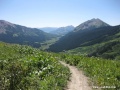
401 트래일
콜로라도 주 (Colorado) 크래스티드 뷰트 (Crested Butte)에 위치한 세계적으로 유명한 산악자전거 코스; 물론 하이킹으로도 유명하다.
스나드그래스 (Snodgrass)

시작점: 고딕 로드 (Gothic Road)가 비포장으로 바뀌는 지점의 왼쪽에 주차공간과 등산로 시작점이 있다. 또는 루프 코스로 묵는 호텔에서 시작할 수도 있다.
10 마일 정도 루프 코스로 시간이 많이 없을때 좋은 코스이다. 짧지만 숲으로 (Snodgrass) 들어가서 빽빽한 애스핀 나무들 사이로 즐기는 2 마일 정도의 나이스 싱글트랙 다운힐이 바이커들을 즐겁게 하여준다.
- 마운틴 크래스티드 뷰트 한 콘도에서 시작한 루프
- 콘도에서 어렵지 않은 고딕 로드(Gothich Road) 포장도로를 1.5 오르니 도로가 비포장으로 바뀌는 부분에 왼쪽으로 주차공간과 트래일 시작 부분
- 소방도로를 조금오른후 나이스 싱글트랙 오르기 약 1 마일
- 싱글트랙 삼거리에서 왼쪽으로, 그리고 1 마일 오르니 개이트
- 개이트에서 조금 오른후 나이스 다운힐 시작; 약 2 마일 정도, 아름다운 나무들 사이로 very very nice sigle track
- 개이트 (철사로 막혀있는) 를 나와서 싱글트랙을 약 1 마일 내려가니 비포장도로 (Washington Gulch Road)
- 이도로에서 좌회전하여 조금오른후 계속내려옴, 도로는 포장도로로 바뀌고 꽤 빨른 속도로 내려올 수 있음
- 도로는 고딕 로드를 만나고 여기서 좌회전하여 콘도로 영차영차 1 마일 오름
GPS data
- Distance 9.6 mi
- Min Alt 1.721 mi
- Max Alt 1.897 mi (10,016 피트: 3,052 미터)
- Max Speed 33.4 mph
- Avg Speed 6.9 mph (1 시간 30 분 정도)
고도 변화

Strand Hill
크리스티드 뷰트 지역에서 401 다음으로 유명한 트래일; 401 보다 더 태크니칼한 섹션이 많음
그리고
이외에도 좋은 산악자전거 트래일이 많이 있다. 크래스티드 뷰트에 도착하면 호텔이나 자전거 대여점에서 트래일 맵을 구할 수 있다.
등산 (하이킹)

쿠퍼크릭 트래일 (Copper Creek Trail)
시작점: 고딕 (Gothic)의 작은 다운타운을 지나 1/2 마일, 오른쪽에 주차공간.
경사가 심하지 않은 트래일로 사시나무와 돌로 되어있는 산책길을 1 마일 가면 Judd Falls 폭포가 나온다. 이 곳에서 조금만 가면 옆으로 주디 폭포에 접근하는 곳이 나와서 우리 아이들은 밑으로 내려가 잠시 통나무다리를 두팔을 벌리고 오며갔다. 잠시 물가에서 놀다가 올라와 4 마일 가면 Copper Lake 호수 그리고 더 많이 많이 가면 애스핀 (Aspin) 까지 이어진다고 한다. 이 길은 늦은 봄부터 여름에 야생화로 절경을 이룬다. 경사가 많이 없지만 고도가 높아 금방 피로를 느낀다. 하이커들의 컨디션에 따라 하이킹 거리를 정한다.
그리고
이외에도 좋은 하이킹 트래일이 많이 있다. 크래스티드 뷰트에 도착하면 호텔이나 비지터 센터에서 트래일 맵을 구할 수 있다.
- Beaver Ponds Trail #516: This is an easy trail, approximately 1/2 mile in length and has benches and interpreative signs. The trail begins off the Ohio Creek Road 22 miles north of hwy 135 and ends at a large beaver pond where a picnic ground is provided. Fishing is available in the ponds.
Difficulty: Easy
- Boulder Creek Trail #478: The trail head is out of Gold Creek Campground. The trail climbs steadily, with lots of switch backs, to Boulder Lake. 8 Miles round trip.
Difficulty: Strenuous
- Conundrum Trail #1981: The trail leaves one mile west from Gothic (trail 739), hike up to Judd Falls following the Copper Creek trail. Continue along until markers to Copper Pass/Triangle Pass (trail 1981) are seen. Follow the trail over Triangle Pass and down into the valley along Conundrum Creek, this leads to Conundrum Hot Springs. The trail winds through forests and eventually along steep, slide hill with much loose rock. 9 miles one way.
Difficulty: Strenuous
- Curecanti Creek: It descends from the rim of the upper Black Canyon to Morrow Point Lake, following Curecanti Creek. It ends at the lake with a view of the Curecanti Needle. 4 miles round trip. The trail head begins at Pioneer Point, off hwy 92, 5.7 miles west of it's junction with hwy 50.
Difficulty: Moderate
- Dyke Trail: You should arrange for car shuttle if hiking this trail. Leave one car at Horse Ranch Park, where hike will end. Take Kebler Pass Road (County Road 12) west for 6 miles, then turn right to Irwin Lake (Forest Road 826). Drive to Irwin Campground and park. Hike up road, then fork left. Continue on jeep road for about 1/2 mile. Look for Dyke Trail signs on left. 5 - 6 miles.
Difficulty: Moderate
- Elk Creek/Gunsight Pass: Take Kebler Pass Road west for 4.6 miles to a steep ravine on your right. Park here. Hike trail on right up left side of stream. At the Standard Mine, take right road uphill to the top of Gunsight Pass. Return down the same way you came. You can see many old mines on this hike; avoid shafts, dangerous openings and equipment. 4 - 5 miles.
Difficulty: Strenuous
- Green Lake: Start from the Crested Butte Nordic Center at 2nd and Whiterock. Follow the trail up the Bench southbound. Turn right on Wildcat Road, continue on trail past dead end of road. Turn right on Trapper's Crossing Road. Watch for sign to Green Lake Trail on left. Gorgeous picnic spot. 7 miles round trip.
Difficulty: Moderate
- Henry Lake #429: The trail takes off at Lottis Creek Campground (in Taylor Canyon) and is 14 miles round trip. It is rough and steep. There is fishing at Henry Lake.
Difficulty: Strenuous
- Lamphier Lake Trail #428: The trail head is out of Gold Creek Campground, 100 yards past the campground itself. The trail follows the creek, winding its way through aspen and pine up to the remote lake. 6 miles round trip. The trail head is on the top of Gunsight Pass, one more mile.
Difficulty: Moderate
- Mill Castle Trail #450: The trail begins on Mill Creek Road, a two wheel drive road. The trail goes over Storm Pass (12,440ft.) and very steep on both sides. This is one of the most scenic trails in the West Elk Wilderness, but only experienced hikers should attempt this 14.3 mile hike. The first 5 miles are easy, the rest is more strenuous.
Difficulty: Moderate
- Mysterious Lake: Starts off Trail Creek Road approximately 5 miles from Spring Creek Reservoir. It is 5 miles long. Some previous hiking experience is desirable. There is fishing at Mysterious Lake.
Difficulty: Moderate
- Neversink Trail: short trail along the Gunnison River, leaving from Neversink day use area in Curecanti National Recreation Aread on Highway 50, 5 miles west of Gunnison. the tree shaded walk is 1.5 miles round trip on flat terrain.
Difficulty: Easy
- Peanut Lake/Lower Loop: Probably the most popular "quick trail" because of its vicinity. On the corner of 1st street and Elk, go north on on 1st. Then turn left on Butte Ave. Park your car on the side of the road and walk Peanut Road to Peanut Lake. The trail will turn into Lower Loop. 2 to 3 miles. Great beginner trail or when hiking with small children.
Difficulty: Easy
- Snodgrass Mountain: Take Gothic Road north past the stables. Park at Snodgrass trailhead on left. Cross over fence stile form. Please obey any seasonal closure signs on gate. You can reach the top of Snodgrass Mountain on the dirt road. Trail to left past second gate, ends in Washington Gulch. 5 miles to top and back.
Difficulty: Moderate
- Splain's Gulch: This one is a nice short hike. Start off west on Kebler Pass Road (County Road 12). Drive 5 miles to Forest Road 885. Turn left and park. Hike on the road or various trails. This hike is 4 miles with beautiful forest.
Difficulty: Easy
- Strand Hill/Ferris Creek: Take Hwy. 135 south for 2 miles. Turn left at Brush Creek Road and follow past Cold Springs Ranch (on your left). Park about 1/2 mile past the ranch at trailhead on your right. Walk a short distance to Ferris Creek Road. Remember to close gates behind you. Trail is steep in places for about one mile, then levels out. At fork on top of hill, follow dirt road to Ferris Creek and around Strand Hill. Alternatively, at the fork turn left and climb Strand Hill. After two miles of climbing, turn left on singletrack into a meadow and descend through aspen forest for several miles. At the botom, follow the trail right, then left to Brush Creek Road. This hike is 5-6 miles long.
Difficulty: Moderate
- Summerville Trail #430: Summerville trail begins in Taylor River Canyon, approximately 1 mile below Lodgepole Campground, and goes through Crystal Creek Drainage to fossil Ridge. The trail is approximately 11 miles long. The area is remote and few people go into it. Steep with switchbacks.
Difficulty: Strenuous
- Swampy Pass Trail #439: The trail head is located off Ohio Creek Road (County Rd 730). The trail climbs gradually through aspen and pine overlooking the scenic Ohio Valley and the Castles. 8 miles to Swampy Pass.
Difficulty: Moderate
- Timberline Trail #414: This trail starts just below Mirror Lake Campground and crosses the Cottonwood Pass Road 8.5 miles to the north. Both points are accessible by automobile. Timberline Trail offers superb views of Taylor Park.
Difficulty: Moderate
- Upper Loop: This is a 6 mile hike. Hikers take opposite direction to bikers. From the new school, follow road past gravel mine on Town Ranch to Brush Creek Road. Turn left, then left again on Skyland Drive. Trail continues past gate at Grant Lake and ends on Hunter Hill Road in Mt. Crested Butte. Return down Gothic Road to Crested Butte. Great scenery of the Mountain and Town.
Difficulty: Moderate
- Walrod Gulch Loop: Starting from the Town of Crested Butte, take Hwy. 135 south 6.8 miles to Cement Creek Road. Turn left and continue on Cement Creek Road for 1.5 miles. Park in turnout at Trail #409 trailhead. Begin trail at #409 trailhead climbing steeply up trail and enjoying forest scenery as well as caves towards your right. At top, take right fork and follow to Walrod Gulch jeep road. Turn right on road and descend to Cement Creek Road. Turn right to return to vehicle. 3 - 4 mile trail.
Difficulty: Moderate
- Yule Pass: Take Gothic Road north from Crested Butte, past the cemetery. Turn left on Slate River Road and continue for about 9.5 miles to Paradise Divide. Road is steep and narrow at the top. Park at Paradise Divide and hike on jeep road to Yule Pass. You can also hike off-trail to Treasury, Purple or Cinnamon Mountains from Yule Pass Trail. You'll see great views and many wildflowers. 4 miles.
Difficulty: Moderate
겨울스포츠 (스키)
- Crested Butte Mountain Resort 홈페이지
- 정상 고도: 12,162 feet3,648.6 m (3,707 m)
- 배이스 고도: 9,375 feet (2,858 m)
- 고도 변화: 849 m2,830 feet
- 슬로프 면적: 1,125 acres4.5 km²
1.8 miles²
1,377,000 평 (4.55 km²) - 슬로프 수: 121 (23% beginner, 57% intermediate, 20% advanced/expert)
- Longest run: 2.6 miles (4.2 km); Peak to Treasury
- 리프트 수: 15
관련 문서
검색: 콜로라도 주
- 2009 로얄고지 (Royal Gorge)
- 2009 로키마운틴
- 2009 샌환 (San Juan)
- 2009 콜로라도 스프링스
- 2009 콜로라도 슬라이드 1,2
- 2009 콜로라도 슬라이드 4
- 2009 콜로라도 슬라이드 5
- 2009 콜로라도 슬라이드 6
- 2009 콜로라도 슬라이드 7
- 2009 콜로라도 여행
- 2009 크래스티드 뷰트
- 2009 하이웨이 70
- 401 트래일 (401 Trail)
- 거니손 국유림 (The Gunnison National Forest)
- 골든게이트 캐년 주립공원 (Golden Gate Canyon State Park)
- 글랜우드 스프링스 (Glenwood Springs)
- 댄버 (Denver)
- 듀랭고 (Durango)
- 로얄 고지 (Royal Gorge)
- 로키마운틴 국립공원 (Rocky Mountain National Park)
- 메사버드 국립공원 (Mesa Verde National Park)
- 모나크 크래스트 트래일 (Monarch Crest Trail)
- 뮐러 주립공원 (Meuller State Park)
- 미공군 사관학교 (United States Air Force Academy)
- 밀스 래이크 트래일 (Mills Lake Trail)
- 배일 (Vail)
- 베타소 보호구역 (Betasso Preserve)
- 볼더 (Boulder)
- 브래큰리지 (Breckenridge)
- 블랙캐년 국립공원 (Black Canyon of the Gunnison National Park)
- 샌환 관광도로 (San Juan Skyway)
- 스노우메스 빌리지 (Snowmass Village)
- 스테이트 포레스트 주립공원 (State Forest State Park)
- 신들의 정원 (Garden of the Gods)
- 아스펜 (Aspen)
- 에머랄드 래이크 트래일 (Emerald Lake Trail)
- 원터파크 (Winter Park)
- 콜로라도 겨울스포츠
- 콜로라도 국립기념물 (Colorado National Monument)
- 콜로라도 등산 (하이킹)
- 콜로라도 산악자전거
- 콜로라도 스프링스 (Colorado Springs)
- 콜로라도 캠핑
- 쿠퍼 마운틴 (Copper Mountain)
- 크래스티드 뷰트 (Crested Butte)
- 텔류라이드 (Telluride)
- 파이크스 피크 (Pikes Peak)
주요 정보
개요
- 요약: 콜로라도 야외활동의 숨겨진 보물
- 면적 : 0.7 sq mi437.5 acres
535,500 평
1.75 km² (1.8 km2) - 고도 : 8,924 ft2,677.2 m (2,720 m)
- 인구 : 1,529 (2000 년)
- 지역 관광 평가 : 5
- 산악자전거 평가: 5
- 등산 (하이킹) 평가: 5
- 자전거 대여
- 근처지역: 콜로라도 주
랜탈 (스키, 산악자전거)
Crested Butte Mountain Resort에 위치하고 있음
- crestedbuttesports
- 1-800-301-9169 cannodale 자전거
- 추천: 매우친절함
- flatironsports.net in side of Crested Butte Mountain Resort
- 1800 821 4331, 970 349 5373 kona 자전거
위치
멀티 미디어
유튜 비디오 (youtube.com)
Nature Valley Energy Bar 광고 (아래의 유튜브 자료)라 크래스티드 뷰트 지역이 속하고 있는 엘크 산맥 (Elk Mountains)에서 찍었다. 자세히 알려지지는 않았지만 경치로 보아 크래스티드 뷰트 근처의 트래일에서 찍으것으로 보인다.
- Elk Mountains 롹키 산맥에 속해있는 지류 산맥으로 Castle Peak (14,265 ft), Maroon Peak (14,156 ft), Capitol Peak (14,130 ft), Snowmass Mountain (14,092 ft), Pyramid Peak (14,018 ft), and North Maroon Peak (14,014 ft), Mount Sopris (12,953 ft), Cathedral Peak, 13,943 ft (4,250 m), Hagerman Peak, 13,841 ft (4,219 m), Snowmass Peak, 13,620 ft (4,151 m), Clark Peak, 13,580 ft (4,139 m), Treasure Mountain, 13,528 ft (4,123 m), Mount Owen, 13,058 ft (3,980 m), Chair Mountain, 12,721 ft (3,877 m), Crested Butte, 12,162 ft (3,706 m), Whitehouse Mountain, 11,975 ft (3,650 m) 등이 이 산맥에 속하고 있다.
사진 모음

크래스티드 뷰트 타운 - Kebler Pass Rd에서

Snodgrass 등산로 입구

Snodgrass 에서 보는 Crested Butte

Snodgrass 에서 북동쪽

Snodgrass 싱글트랙 시작

애스핀과 Snodgrass 싱글트랙

Snodgrass 와 나와 CB 다운타운

Washington Gulch Rd에서 보는 Gothic Mt (12,625 ft)

고딕산 (Gothic Mt: 12.625 피트)을 배경으로 형과

아름다운 들꽃들과 풍경

하이킹

Judd Falls 폭포

계속되는 트래일

저산을 넘으면 아스핀

개울에서 놀기

트래일에서 보는 고딕산

산악자전거 출발전 (401 루프)

작은 고딕 타운

고딕타운의 비지터스 센터

Mt Baldy를 배경으로 낚시
Emerald Lake 호수

Schofield Pass

Schofield Pass

401 트래일 시작점

401 트래일

들꽃 사이로 401

401 업힐을 잘도 오르는 바이커

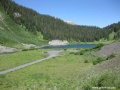
Treasure (13,461), Snowmass(14,091), Maroon Bells(14,156), Pyramid Peak(14,018)

401 다운힐 시작
크래스티드 뷰트 산과 밸리

크래스티드 뷰트 산과 밸리 2

산의 허리를 감아도는 싱글트랙 (가운데 가늘게)

Rustler Gulch 에서

이어지는 401 싱글트랙

만난 Georider (mtbr.com) - 401 트래일을 만든 주인공

Crested Butte Sports

Crested Butte Mt (12,162 ft)

Crested Butte City Hall

Gothic Rd의 라이더들

Mt. Crested Butte 타운

Three Season 콘도


